Comprehensive Natural Disaster Monitoring and Early Warning System
Emergency management work requires guidance for emergency response to two major categories of disasters: production safety and natural disasters. The guidelines emphasize the need to build comprehensive natural disaster monitoring and early warning systems, as well as production safety risk monitoring and early warning systems. In the construction of the emergency management integrated application platform, the comprehensive natural disaster monitoring and early warning system is built on the basis of integrating and sharing disaster data from multiple departments. This system effectively enables coordinated operation of government departments at all levels, providing professional emergency information services for early warning, command decision-making, and emergency response to major emergencies, and comprehensively improving government emergency management capabilities and levels. Based on 22 years of experience in disaster reduction and utilization, big data accumulation, and technical support, ISTRONG has launched a comprehensive natural disaster monitoring and early warning system solution.Comprehensive Natural Disaster Monitoring and Early Warning System
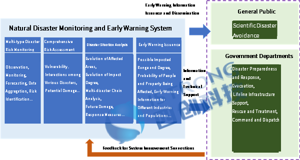
The construction of the comprehensive natural disaster monitoring and early warning system mainly consists of four aspects: multi-hazard risk monitoring, integrated risk assessment, disaster situation analysis, and disaster early warning release.

1、Multi-hazard risk monitoring
On one hand, it collects and shares basic, forecast, and real-time monitoring data of meteorological disasters, water and drought disasters, geological disasters, earthquake disasters, and forest and grassland fires from industry sector authorities, realizing dynamic perception of disaster risks. On the other hand, remote sensing technology can be used to identify and monitor disaster anomalies, as well as to monitor the geographic location and surrounding environment of natural disasters such as forest and grassland fires, dam breaches, and typhoons in real-time.


2、Integrated risk assessment
Based on the basic data, real-time monitoring data, remote sensing data, and historical disaster data of natural disasters in the region, using natural disaster risk assessment models, artificial intelligence, and knowledge graphs, the system quantifies and assesses the likelihood of different intensity disasters and their possible consequences. This generates a natural disaster risk map, providing technical support for natural disaster risk management.


3、Disaster situation analysis
Based on the comprehensive risk assessment results, forecast data, perception data, and other natural disaster-related data, the system employs various disaster situation analysis models, big data analysis, and artificial intelligence technologies to form disaster development trend projections. This assists decision-makers in judging the future development trends of disasters and analyzing multi-hazard disaster chains. Furthermore, the system supports the provision of disaster response plans based on the evolving trends, offering a reference for the advance deployment of natural disaster emergency management tasks.


4、Disaster warning release
Based on the natural disaster emergency response plan system, comprehensive risk assessment results, and disaster situation analysis results, the system supports the automatic generation of natural disaster warning information according to warning rules. This ensures that warning information is directionally and accurately pushed to relevant responsible persons, staff, and the general public.

